|
|
QueryMapExtentTool |
|
|
|
|
QueryMapExtentTool |
|
|
With the QueryMapExtentTool you get a list of map objects within the current map section.
Thus, it can be used in the map, activate and configure it within the toolbars menu.
The activation is done by checking the checkbox. The configuration can be reached by pressing the edit buttons.

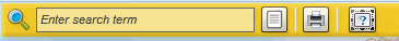
If the tool is configured and activated, it can be called in the map by clicking the button  .
.
NOTE: The tool is available in the current version exclusively within the Flex client.
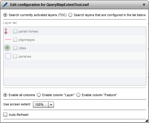
Only the layers which are activated within the map will be recognized for generating the result list.
From the list of layers, the layers can be selected that are queried and their features listed in the results of QueryMapExtentTools.
This is done by checking the checkbox in front of the layer name.
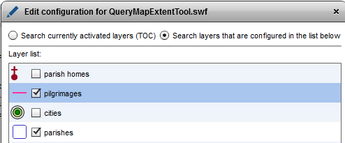
The tool delivers results regardless of whether the layer is checked on or checked off in the TOC:
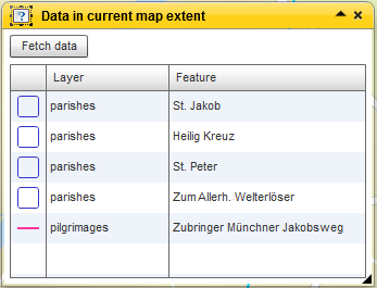
The "Enable all columns" option has the consequence that in the presentation of search results following information will be displayed:
- layer symbol
- layer name
- feature name*
The "Enable column 'layer'" option has the consequence that in the presentation of search results following information will be displayed:
- layer symbol
- layer name
The "Enable column 'Feature'" option has the consequence that in the presentation of search results following information will be displayed:
- layer symbol
- feature name*
*The feature name is configured my setting the Maptips.
Here you indicate the proportion of the map section, which is included for the object detection. A value of 50%, means that only half of the map area, starting from the center of the map for the object detection is included.
Check the checkbox for auto-refresh to get the results of the tool automatically after each zooming and panning.
If the box is not checked, a button is displayed when running the too, with which the search can be started manually.