In this tab you can select the settings for the output files like the output directory and the graphics format.
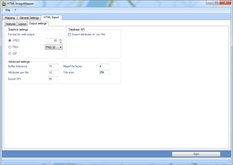
Graphics settings
Here the graphics format for the tiles, i.e. the parts of the actual map, is selected. For further information on the graphics formats and setting options see chapter Graphics formats..
Database API
With the API database you can export the attributes of the used layers into CSV files (CSV: Character Separated Values).
CSV files are suitable for subsequent processing in databases.
Users with programming knowledge gain a variety of possibilities for rearranging the HTML ImageMapper 13.3.2 output according to their likings or using it as a foundation to a new database-supported application. For instance, an own search function can be implemented which makes it possible to search for several attributes of one layer. HTML ImageMapper 13.3.2 projects can thus be better and more easily integrated into existing websites and their logic.
Two files per layer are exported: An SQL file containing the table definition for a layer and a CSV file containing the information of the attribute table and additionally the information in which map sector an object is positioned. The map sectors are saved in the “map” directory as usual.
You can find the API database files in the “dbapi” directory.
Hint: If you want to use the export function, please note that the names of your layers should not contain any special characters, because those will be removed in the export.
Graphics formats
The tiles can be saved in the listed formats with the specified options.
- JPEG:
JPEG is the graphics format used most in the web for photos. The JPEG format is based on a lossy compression algorithm. JPEG is especially recommended if your map contains many colors (e.g. satellite images)
The number in the entry box represents the used quality, a higher quality meaning bigger files and therefore longer loading times for the user. Visually loss-free images are to be expected up to a compression rate of 15 (quality factor 85). Reasonable values with good results vary between 70 and 95.
- PNG:
This loss-free format is recommended if you have got many fine objects in your map. The selection box offers the possibility to choose between “PNG 24” and “PNG 32”, the latter containing an additional channel for transparency. The PNG format accomplishes better compression rates than the JPEG format in images with big, monochrome areas, but is clearly inferior to the latter when it comes to photos.
- GIF:
This somewhat aged graphics format can only save 256 different colors. If your map has few colors, you can select this format. But most of the time the other formats are preferable.
- TIFF:
This format is only available for the tile export.
You can create compressed, completely loss-free tiles with it, if you prefer working with TIFF instead of PNG files.
Please note that this is a so-called “Baseline TIFF” and not a “GeoTIFF" with integrated geo referencing.
Advanced settings
- Buffer tolerance:
Here the range of the click function on objects can be adjusted. The setting "10” means that an object responds to the click function up to a buffer zone of 10 pixels around the actual object.
- Attributes per file:
With this option you can adjust the size of the "Attributes”-Files. These files contain the attribute data of the individual objects. The number in the entry box indicates how much attribute data is saved in a file.
A small value leads to high memory requirements, but it has the advantage that only a short loading time is to be expected by the user.
A high value, on the other hand, minimizes the memory requirements on the data storage medium, but involves a longer waiting period for the map users.
- Export DPI:
Here you can adjust the output resolution of the created tiles, which enables you to calibrate the equalization degree between harsh colour-changes to your liking. Please keep in mind that high resolutions cause higher file sizes of the separate tiles, which means longer loading times in the internet.
- MegaTile - Factor:
The selected map extract is cut in several parts called MegaTiles before creating the tiles. So, objects close to the borders of the MegaTile can be labeled twice.
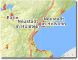
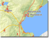
before after
Now, by adjusting the MegaTile-Factor, you can determine by yourself how many MegaTiles are created, you can prevent double-labeling.
A MegaTile-Factor set to 4, means that 4x4 MegaTiles are created.