Images say more than words. But how can I organize picture libraries with thousands of digital photos?
The solution is linking images with the position where they were taken using the GPS-capable digital camera G800SE, G700SE and Caplio 500 SE from Ricoh, with integrated or extern GPS and the software PhotoMapper Desktop 10.4.
In many fields of application of object documentation and management, geo referencing of takings is absolutely necessary. Up to now, this had to be carried out in a time-consuming post-processing, which now becomes superfluous. Already when the picture is taken, the site coordinates are determined with GPS and saved in the picture's header.
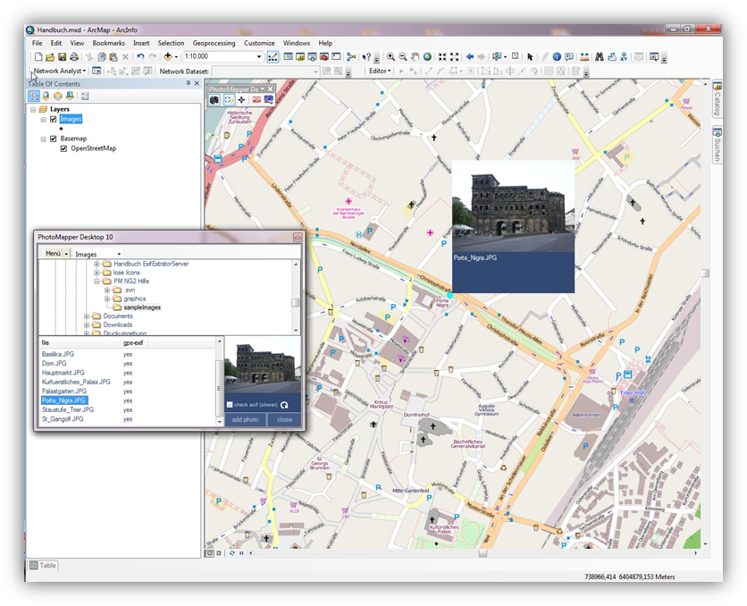
PhotoMapper Desktop 10.4 enables you to make use of this information and embed it in the geographic information system ArcGIS from Esri. The GIS-user can simply access the photos and manage them without any major effort. The Thumbnail Viewer facilitates finding photos with preview images, makes it possible to zoom in on a selected photo and marks pictures without position data.
Older data inventories can be referenced retroactively with PhotoMapper Desktop 10.4.

The possible applications are manifold, reaching from disaster control – where staff members can document the situation exactly on the spot with marks of time and location, making it thus possible for the control center to literally get a picture of the situation – to classical documentation functions in environmental protection or object documentation, e.g. in real estate business, tourism industry or for police and Health and Safety.
PhotoMapper Desktop 10.4 is an extension for Esri’s ArcGIS for Desktop 10.3 and cannot be used as a stand alone module.
First switch on the GPS device and your camera. For the initial startup, please observe the short instruction in the appendix.
Take photos with the G800SE / G700SE / Caplio 500SE from Ricoh. With the pluggable GPS or an extern Bluetooth GPS, the exact time of taking and the geographic coordinates are saved automatically.
First load the digital images from the camera onto your PC and save the data on the hard disk. You can link the camera to your PC with the provided USB cable or use the W-LAN functionality of the camera.
With PhotoMapper Desktop 10.4 you can access all digital pictures and work with them in the geographic information system ArcGIS for Desktop 10.4.
In order to do this, a reference is written into a File-Based Geodatabase, Personal Geodatabase or in a file in the Shapefile format. This reference can either be relative or absolute.
From the coordinates of the location of the taking, a point layer is created. The pictures are linked with these taking points.
Besides, an annotation group can be created with the pictures, whose characteristics can be defined by the user.