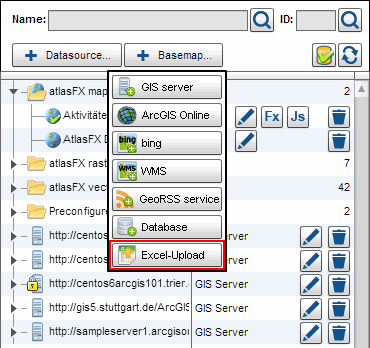
Adding Excel Content
atlasFX allows you to read data from Excel tables with X/Y coordinates and convert it to a point layer. You can also use address data and geocode them. The result is a point layer, with the according attributes. By clicking "Excel-Upload", you are prompted to specify an Excel file.
After the file was uploaded, the following screen pops up, where you can set the address fields manually via drag and drop (if this was not already done automatically). Simply pull the column title in an empty field in the top bar. If an association is faulty, remove the contents from the box.

If the data is all mapped correctly, click  to continue to the geocoder interface.
Note: Currently, the list of matching results is currently only available in German.
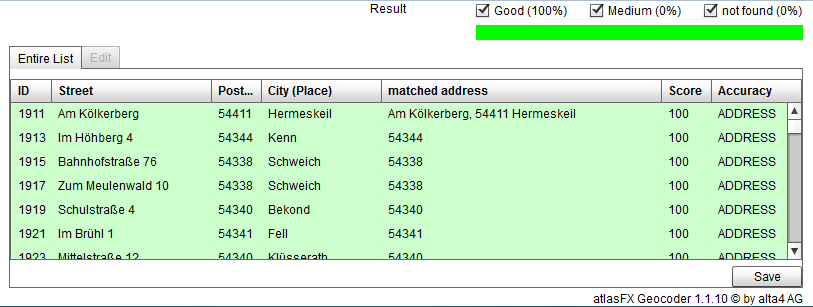
In the geocoder interface you can edit addresses that were not found and insert them manually into the map. to do this make a click on one row of the list. Go to the tab "Bearbeiten". As the case may be you get suggestions on where the address should be. The on a suggestion row shows a mark. Did you identify ist as correct click on the button "Übernehmen". Addresses with 100 as score would be assume automatically when you save the list, you need not confirm them.

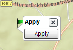
Is there no suitable suggestion you place the address in map manually. To do this navigate to the address, click the button "In der Karte setzen" and then the point in the map. Assume (Button "Übernehmen") the point.
If all addresses are checked, return to the tab "Gesamte Liste" save (Button "Speichern").
Finally, the addresses are saved and available in the atlasFX browser as a point vector layer.