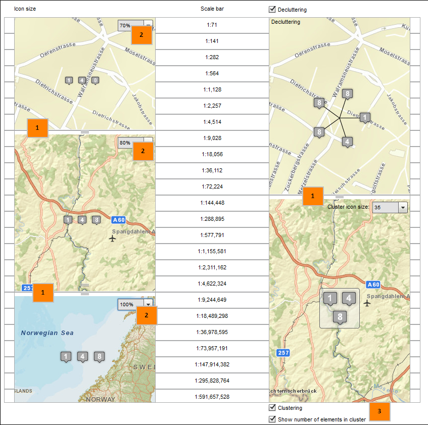
Icon Configuration
In the "Icon configuration" tab, you can create three different icon sizes for different scale ranges and set the display options Decluttering and Clustering.
Drag the white slider (1) to set the scale ranges and icon sizes to the corresponding scale and set to what percentage size (2) of the icon for the enclosed scale range.
Clusters prevent the overlapping of point object icons and ensure a nicer map image. When a cluster is clicked within the map application, the map enlarges to the section at this position and finally dissolves the points to individual symbols when either the distance of the icons to one another is large enough to avoid overlaps or the maximum cluster-scale is reached. If, furthermore, a cluster appears, you can click again on the cluster object and zoom the map.
The configuration of the cluster-icon size also offers you the possibility to show cluster-icons scale-dependent. When selecting the option "Scale" in the dropdown-menu, the icon sizes for each scale are also used for the cluster-icons. This feature is only available in the JavaScript-Client!
Decluttering is a function that pulls individual point features apart to avoid overlapping. The symbols are referenced with lines. This ensures a legible map display with high feature density.
With the checkboxes "decluttering" and "clustering" you can easily enable or disable these functions. The scale level which should be used for decluttering or clustering can be set using the slider on the right side (1).
If the decluttering-checkbox is activated in the icon configuration, the function is activated for every existing point layer. When adding a new layer to the map, decluttering is disabled by default. Then, decluttering has to be activated for every layer individually ("Displace overlapping symbols", see chapter Layer Info). Alternatively, decluttering can be activated simultaneously for all layers in the icon configuration by re-enabling the checkbox "Decluttering" and saving the map afterwards.
Activate "Show number of elements in cluster" (3) to display the total number of cluster elements for each cluster. The color of the number depends on the color theme configuration.
Note:
-
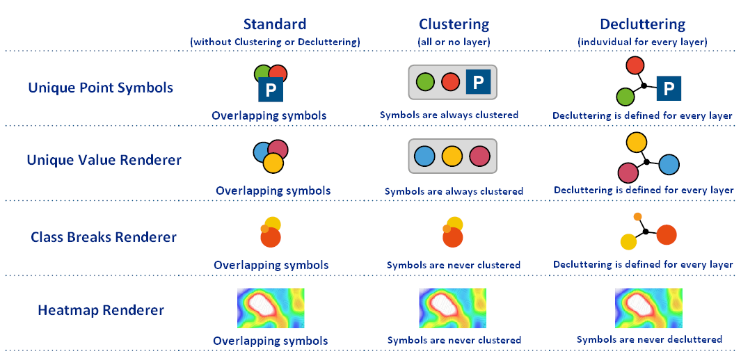
Heatmaps cannot be displayed in a clustered or decluttered way. Geometries of symbology type Class Breaks won't be visualized in clusters. However, they'll be decluttered in the whole scale range. Geometries of symbology type Unique Value aren't displayed in the preview.
-
The visualization of cluster features is restricted by the AGS feature limit. Clusters may loose features when zooming out in case that the limit has been extended. This may result in a misleading number of cluster elements.
-
The grey cluster frame is only visible in the Flex client.
-
The declutter mode has a limit of 150 decluttered features at the current map extent. Is the limit exceeded it is only possible to click on the topmost point. If there are less than 151 Features in the current map extent the decluttering is activated aga
If symbols get clustered or decluttered depends on the chosen symbology type.

In the following graphic it is shown which function is available for which symbology type
-
Unique symbol -> Unique Point Symbols
-
Unique value -> Unique Value Renderer
-
Class breaks -> Class Break Renderer
-
Heatmaps -> Heatmap Renderer