RoutingTool
The tool is used exclusively in the Flex client. Before the tool can be configured the map client must be set to Flex.
With the routing tool you can calculate a route on your map. For this tool you need a geocoding service and Network Analyst for ArcGIS Server to be present. Without these prerequisites, the tool can not be used.
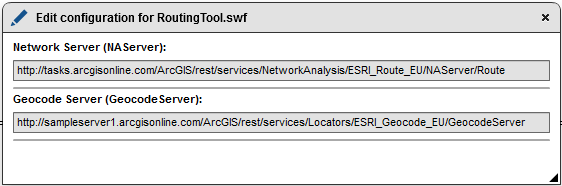
You have to set a Network Server and a Geocoder Server for this tool. Your clients can use this tool with the button "Get directions".

With a click on your map you can choose if you want the "Directions from here" oder "Directions to here"

After the route has been calculated, the selected track will be highlighted. In the tool window "Get Directions" individual sections can be selected with the mouse. The relevant section is color coded and then by clicking on it the tool zooms to the corresponding road section.
